By Weather Desk | sbkinews.in
Date: August 17, 2025
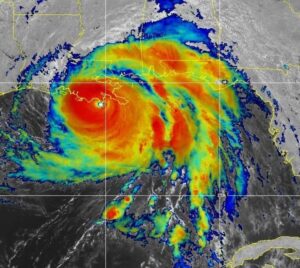
A Storm of Extraordinary Power
Hurricane Erin, the first major hurricane of the 2025 Atlantic season, has rapidly intensified from a tropical storm into a Category 5 “catastrophic” hurricane within just a day, delivering a sharp warning to the Caribbean. Packing sustained winds of 160 mph (255 km/h), Hurricane Erin is expected to grow larger as it tracks north, threatening the Bahamas, Turks and Caicos, and possibly the U.S. East Coast as a significantly enlarged storm system.
What Happened: The Meteorological Journey
Date of Formation: On August 11, Erin transformed from a tropical wave off the coast of West Africa into a tropical storm.. It underwent explosive intensification, reaching Category 4 by early August 16 and Category 5 shortly thereafter.Eyewall Replacement & Expansion: The storm is now undergoing an eyewall replacement cycle, temporarily weakening to Category 3 with winds near 125 mph (205 km/h). Despite this, it is growing significantly in size, with hurricane-force winds and rain bands extending hundreds of miles outward.
Forecast Path: Erin is moving west-northwest across warm Atlantic waters. While it will likely remain offshore of the Southeast U.S., its expanded wind field will send dangerous surf, swells, and rip currents along coastal areas from Florida to New England by midweek.
Current Impact: Islands Bracing for the Worst
Caribbean Effects: Rain bands have unleashed heavy downpours (up to 8 inches), as well as flash flooding and landslide risks across the Virgin Islands and Puerto Rico. Power outages and flight disruptions are widely reported.Alerts & Warnings:
Tropical storm watches are active for Turks and Caicos and parts of the Bahamas.
The U.S. National Hurricane Center also advises dangerous ocean swells for Bermuda and the U.S. East Coast.
The Economic TimesThe Washington Post
Flight & Port Disruptions: Ports in Puerto Rico and the U.S. Virgin Islands have been closed, and flights canceled. FEMA has deployed over 200 staffers to Puerto Rico to assist emergency operations.
What’s Next? Key Forecast Highlights
| Forecast Scenario | Details |
|---|---|
| Reintensification | Erin may climb back to Category 5 after its eyewall cycle. |
| Size Expansion | Expected to double or triple in diameter, vastly extending its impact zone. |
| Offshore Track | Forecast to pass between Bermuda and the U.S. East Coast without landfall. |
| Coastal Effects | Dangerous rip currents and storm tides expected from Florida up to New England. |
Leading meteorologists warn that larger, slower-moving hurricanes carry greater energy, increasing the risk to coastal communities, even without landfall.
AxiosFOX WeatherThe Washington Post
Hurricane Erin
Climate Context: More Storms, Faster Intensification
Erin’s rapid shift from tropical storm to Category 5 in under 24 hours is a hallmark of modern hurricanes fueled by warming sea surface temperatures and higher atmospheric moisture—both climate change symptoms. This makes timely forecasting and public response ever more critical.
The GuardianAxiosWikipedia
Hurricane Erin
Final Take
Hurricane Erin is far more than a weather event—it’s a compelling reminder of the heightened volatility in our warming world.Preparation and awareness are still crucial throughout the Caribbean and the United States as the storm grows stronger and wider. East Coast. Erin may avoid landfall, but its legacy of powerful swells, torrential rain, and coastal danger is unfolding fast.
Stay updated and stay safe.sbkinews.in