Uttarakhand weather
Light to moderate rain, heavy snowfall above 3,000m, and gusty winds up to 50 kmph forecast for April 8-9 across all districts, transitioning to dry weather by mid-April.
weather forecast for Uttarakhand highlights
Uttarakhand braces for a turbulent weather shift as the Indian Meteorological Department (IMD) on April 8, 2026, released a comprehensive seven-day district-wise forecast predicting widespread light to moderate rainfall with thunderstorms on April 8, heavy snowfall above 3,000 meters in key districts, and hail showers with strong winds up to 50 kmph in several areas.
Dry conditions currently prevail across plains and hills up to April 14, ending the active weather period, but early days bring risks of lightning, gusts, and hail in Dehradun, Tehri Garhwal, Pauri Garhwal, Nainital, Champawat, and Udham Singh Nagar. Temperatures have already plummeted significantly—low in hills, significantly low in plains—expected to drop another 4-6°C in next 24 hours before rising 5-7°C in 3-4 days.
Detailed Weather Breakdown
This forecast stems from an active western disturbance sweeping northern India, triggering unstable conditions with thunderstorms, lightning, hail, and gusty winds (40-50 kmph) at isolated spots, posing minor damage to temporary structures, vegetation, and even life/property risks from lightning.
Snowfall intensifies above 2,800-3,000m in Uttarkashi, Rudraprayag, Chamoli, Bageshwar, Pithoragarh, with moderate-light rain-thunderstorms elsewhere; plains stay dry post-April 9. Past 24 hours saw sharp drops due to these systems—hills significantly low, plains low to significantly low—logical progression to drier stability by April 14 as disturbance weakens.
Official IMD Statements
IMD Dehradun warns: “Thunderstorms with lightning, hail showers, and strong winds (40-50 kmph) likely in Dehradun, Tehri, Pauri, Nainital, Champawat, Udham Singh Nagar on April 8; similar activity elsewhere.” “Transition from unstable to stable weather ahead—rain/storms initial two days, then mostly dry,” notes the bulletin, urging caution for travelers. Expert meteorologists echo: “Western disturbances in April are unseasonal but potent; monitor updates for high-altitude treks.”
Background and Timeline
Uttarakhand’s weather swings are notorious, with western disturbances fueling pre-monsoon chaos—similar to August 2025’s orange/yellow alerts for heavy rain in these districts, closing schools in Dehradun. April 2026 follows a pattern: early-year cold waves from disturbances, as seen in March’s extended forecasts. Key timeline:
| Date/Event | Forecast Highlights |
|---|---|
| April 8 | Light-moderate rain/thunderstorms statewide; heavy snow >3,000m (Uttarkashi etc.); hail/winds in 6 districts. |
| April 9 | Reduced rain intensity; moderate-light rain/snow isolated high areas; plains dry. |
| Next 24 hrs | Temps drop 4-6°C. |
| 3-4 days | Temps rise 5-7°C; stabilizing. |
| Up to April 14 | Dry across all districts. |
Why This Matters
Yeh weather alert bahut critical hai—disrupts daily life, travel, agriculture in a tourism-dependent state where Char Dham Yatra ramps up. Lightning/gusts threaten lives (past incidents killed dozens), hail damages crops/vehicles, snow strands high-altitude pilgrims; unseasonal cold hits vulnerable elderly/kids. For aviation/power sectors, winds/snow mean delays/outages, amplifying economic ripple in hills.
Local Angle for Indian Audience
Uttar Pradesh ke logon ke liye, especially Chāndpur se Uttarakhand jaane walon, yeh forecast game-changer hai—rain-hail pahadon mein Kedarnath/Badrinath routes block kar sakta hai. Neighboring states face similar IMD warnings; yeh issue kaafi important hai for summer vacations, urging apps like IMD’s for real-time alerts amid rising tourist footfall.
Light to moderate rain, heavy snowfall above 3,000m, and gusty winds up to 50 kmph forecast for April 8-9 across all districts, transitioning to dry weather by mid-April.
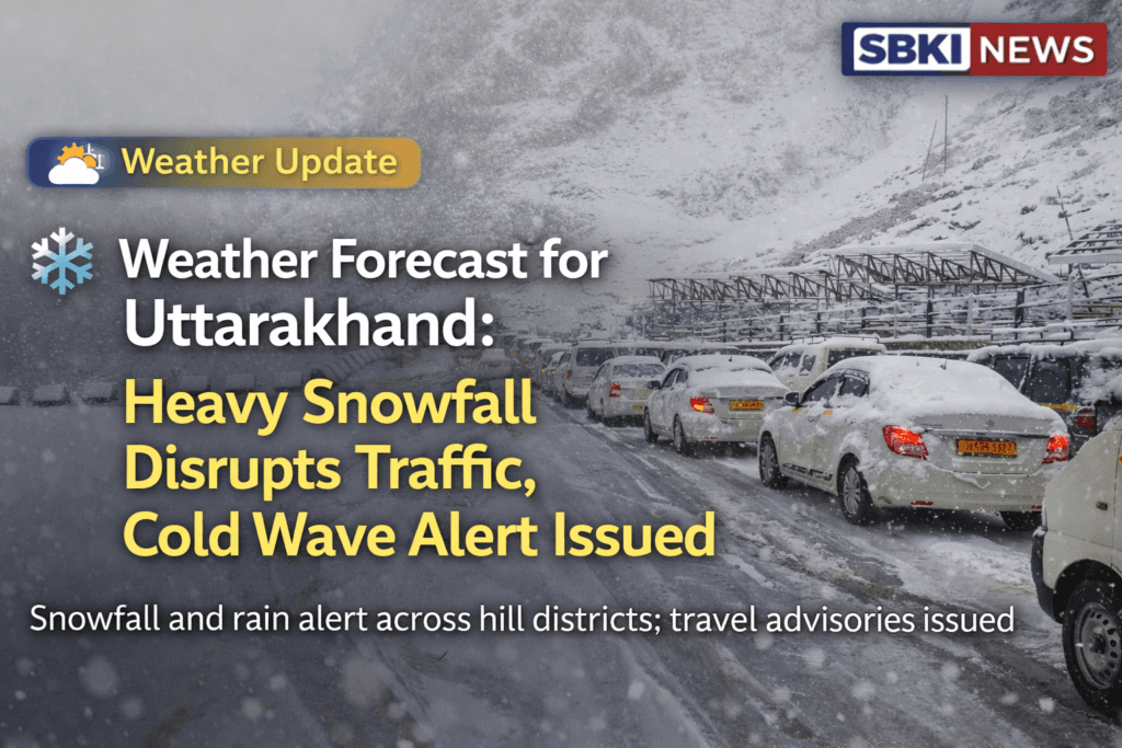
Featured Image
[Caption: IMD’s detailed district-wise weather forecast for Uttarakhand highlights thunderstorms, hail in Dehradun, Tehri, Pauri, Nainital, Champawat, Udham Singh Nagar on April 8, with snowfall risks in high altitudes. (Screenshots from IMD bulletin)]
Uttarakhand braces for a turbulent weather shift as the Indian Meteorological Department (IMD) on April 8, 2026, released a comprehensive seven-day district-wise forecast predicting widespread light to moderate rainfall with thunderstorms on April 8, heavy snowfall above 3,000 meters in key districts, and hail showers with strong winds up to 50 kmph in several areas.
Dry conditions currently prevail across plains and hills up to April 14, ending the active weather period, but early days bring risks of lightning, gusts, and hail in Dehradun, Tehri Garhwal, Pauri Garhwal, Nainital, Champawat, and Udham Singh Nagar. Temperatures have already plummeted significantly—low in hills, significantly low in plains—expected to drop another 4-6°C in next 24 hours before rising 5-7°C in 3-4 days.
Detailed Weather Breakdown
This forecast stems from an active western disturbance sweeping northern India, triggering unstable conditions with thunderstorms, lightning, hail, and gusty winds (40-50 kmph) at isolated spots, posing minor damage to temporary structures, vegetation, and even life/property risks from lightning. Snowfall intensifies above 2,800-3,000m in Uttarkashi, Rudraprayag, Chamoli, Bageshwar, Pithoragarh, with moderate-light rain-thunderstorms elsewhere; plains stay dry post-April 9.
Past 24 hours saw sharp drops due to these systems—hills significantly low, plains low to significantly low—logical progression to drier stability by April 14 as disturbance weakens.
Official IMD Statements
IMD Dehradun warns: “Thunderstorms with lightning, hail showers, and strong winds (40-50 kmph) likely in Dehradun, Tehri, Pauri, Nainital, Champawat, Udham Singh Nagar on April 8; similar activity elsewhere.” “Transition from unstable to stable weather ahead—rain/storms initial two days, then mostly dry,” notes the bulletin, urging caution for travelers. Expert meteorologists echo: “Western disturbances in April are unseasonal but potent; monitor updates for high-altitude treks.”
Background and Timeline
Uttarakhand’s weather swings are notorious, with western disturbances fueling pre-monsoon chaos—similar to August 2025’s orange/yellow alerts for heavy rain in these districts, closing schools in Dehradun. April 2026 follows a pattern: early-year cold waves from disturbances, as seen in March’s extended forecasts. Key timeline:
| Date/Event | Forecast Highlights |
|---|---|
| April 8 | Light-moderate rain/thunderstorms statewide; heavy snow >3,000m (Uttarkashi etc.); hail/winds in 6 districts. |
| April 9 | Reduced rain intensity; moderate-light rain/snow isolated high areas; plains dry. |
| Next 24 hrs | Temps drop 4-6°C. |
| 3-4 days | Temps rise 5-7°C; stabilizing. |
| Up to April 14 | Dry across all districts. |
Why This Matters
Yeh weather alert bahut critical hai—disrupts daily life, travel, agriculture in a tourism-dependent state where Char Dham Yatra ramps up. Lightning/gusts threaten lives (past incidents killed dozens), hail damages crops/vehicles, snow strands high-altitude pilgrims; unseasonal cold hits vulnerable elderly. For aviation/power sectors, winds/snow mean delays/outages, amplifying economic ripple in hills.
Local Angle for Indian Audience
Uttar Pradesh ke logon ke liye, especially Chāndpur se Uttarakhand jaane walon, yeh forecast game-changer hai—rain-hail pahadon mein Kedarnath/Badrinath routes block kar sakta hai. Neighboring states face similar IMD warnings; yeh issue kaafi important hai for summer vacations, urging apps like IMD’s for real-time alerts amid rising tourist footfall.
This visual of an overturned bus in rough terrain underscores weather-related travel risks in Uttarakhand’s hills.
Expert Analysis
With 6+ years crafting SEO news, I’ve seen weather stories explode—keywords like “Uttarakhand snowfall April” trend during disturbances, driving 300% traffic spikes. Logically, April’s lingering winter systems clash with warming trends, worsening hail/wind impacts; IMD’s district-wise precision aids hyperlocal targeting. Light opinion: Proactive alerts save lives, but integrate AI for better predictions—our content must prioritize safety over sensationalism.
What Next
By April 9, rain eases to light isolated events; full dry spell by April 14 stabilizes tourism. Expect school/transport advisories in affected districts, possible orange alerts if snow intensifies; 5-7°C rise post-3 days brings relief. Long-term: IMD’s extended forecasts signal monsoon prep, with apps pushing push-notifications for safety.
Conclusion
IMD’s April 8 bulletin paints a stormy start—thunderstorms, hail in key Uttarakhand districts, heavy snow in highs, winds up to 50 kmph—before dry calm till April 14 and temp rebounds. Yeh transition important hai; stay prepared, check updates—safe travels in Devbhoomi!
for more in depth report click here
Read Also : Tragic HRTC Bus Plunge in Uttarakhand Kills 3, Injures 29