June 8, 2026 – Offshore quake south of General Santos causes local tsunami, widespread damage; coastal evacuations ordered, rescue teams mobilized.
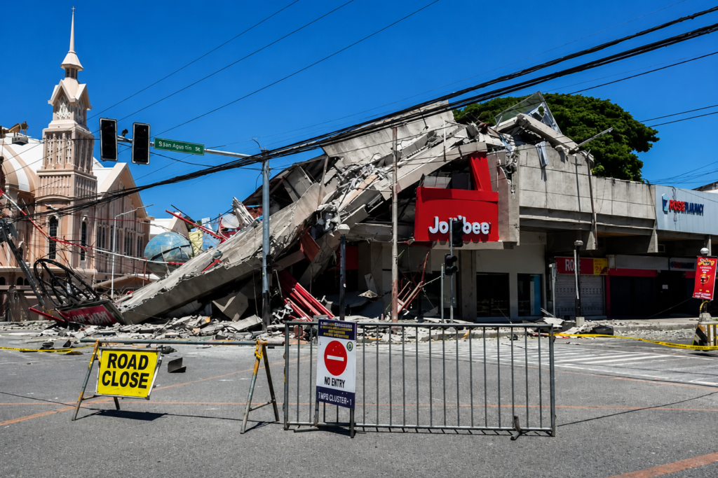
coastal road in southern Mindanao after the offshore magnitude 7.8 earthquake and subsequent 1-metre tsunami hit early on June 8, 2026. / Image credit: PTI
An offshore magnitude 7.8 earthquake struck south of General Santos City on the southern Philippine island of Mindanao early Monday, June 8, 2026, killing at least 15 people and injuring more than 100, officials said. A powerful quake caused damage to buildings and a key access bridge in General Santos, a regional hub of around 720,000 people, and triggered a local tsunami of about 1 meter (3 feet) that struck nearby coastlines.
Officials in coastal towns quickly ordered evacuations to higher ground, while search-and-rescue teams, medical crews, and engineering units fanned out to assess damage and help affected communities.
Why and how this happened
The southern Philippines is part of the Pacific “Ring of Fire,” a complex network of plate boundaries where the Philippine Sea Plate, the Sunda Plate, and the Indo-Australian Plate are converging. The epicenter of the June 8 earthquake and the subsequent tsunami, which occurred offshore, point to a massive seafloor displacement consistent with a large thrust-style rupture or subduction-related fault slip. An event of magnitude 7.8 releases a huge amount of energy, and, if it occurs at shallow depths below or near the sea floor, vertical displacement of the ocean floor could displace columns of water and generate tsunami waves radiating out towards nearby coastlines.
Early seismic data and tsunami monitoring data suggest a relatively shallow rupture that generated strong ground shaking in southern Mindanao and neighboring provinces. Shallow large earthquakes tend to cause more surface shaking and more structural damage and pose a greater risk of generating a tsunami when the rupture has a vertical component.
Besides tectonic forces, local geology and built-environment factors also contributed to the damage. Most coastal barangays are characterized by low-rise or informal housing with minimal seismic reinforcement. Important transport structures like the access bridge in General Santos may have been susceptible to ground motion or ground-settlement effects. Now engineers and seismologists will focus on aftershocks, depth estimates, and rupture mechanics to confirm the exact faulting style and assess tsunami source characteristics.
Casualties, damage and immediate response
Regional civil defense officials said at least 15 people have died and over 100 have been injured. Regional civil defense director Rodrigo Sosmena said 12 of the deaths and 129 of the injuries were in the Soccsksargen administrative region. Emergency services reported building damage at multiple locations, collapsed or badly cracked concrete, and widespread debris in coastal and urban neighborhoods. The collapse or crippling of a main bridge for access to General Santos is putting pressure on relief logistics, with responders forced to reroute supplies and some medical evacuations delayed.
The locally generated tsunami, measured at around a meter at some coastal sites, flooded low-lying shorelines, damaged small ports and boats, and swept debris inland. A 1-meter wave may seem small when compared with the devastating tsunamis of history, but it can cause strong currents, flooding of the coast, and dangerous conditions for people and infrastructure along beaches, estuaries, and river mouths. Authorities warned even modest tsunami waves can be deadly for people caught near the shore or on unstable structures.
The Philippines’ disaster and emergency agencies have placed search and rescue teams, medical triage units, and emergency shelters on alert. Regional and national agencies worked with local government units to set up temporary evacuation centers, send engineering teams to assess bridges and critical facilities, and provide water, sanitation, and medical assistance to displaced families. In some of the affected towns, early assessments of the damage were hampered by disruptions to communications and power.
Voices from the ground and experts
We can confirm multiple deaths and over 100 injured in Soccsksargen. “Teams are already doing searches and helping the families affected,” said Rodrigo Sosmena in an early briefing. Rescuers spoke of early chaotic scenes of families fleeing to higher ground in the darkness after feeling prolonged violent shaking, fishermen watching the sea level retreat and then surge, and neighbors helping others clear debris.
Seismologists underlined the likely cause and immediate concerns. “A magnitude 7.8 offshore event can produce strong shaking over a large area and a local tsunami if the seafloor is displaced,” a regional seismologist said in an expert-style statement. “First and foremost, we’ve got to monitor aftershocks and issue accurate tsunami alerts as engineers assess critical infrastructure for additional risks.”
Background and context
The Philippines is located in a tectonic setting that produces frequent earthquakes and volcanism. It has experienced several devastating earthquakes and occasional tsunamis in its history. Mindanao has experienced seismic activity in the last few decades, and coastal populations are still vulnerable to not only shaking but also tsunami hazards.
General Santos City is an economic powerhouse in southern Mindanao. Fisheries, trade, and agricultural processing are key to livelihoods in the region. Informal settlements and small-scale fishing communities with less resilient housing stock are often situated in coastal barangays here and in neighboring provinces.
There are existing institutions in the country that monitor seismicity and disaster response, such as the Philippine Institute of Volcanology and Seismology (PHIVOLCS), which monitors seismicity and issues technical advisories, and the National Disaster Risk Reduction and Management Council (NDRRMC) and regional civil defense units, which coordinate emergency response and relief. Even the intensity of a big quake and immediate infrastructure damage, such as the compromised bridge in General Santos, strains response capacity and logistics with these systems.
Why this matters
There are many reasons why this earthquake and tsunami matter. First, the human cost is immediate and severe: lives lost, hundreds injured, and the potential for thousands to be displaced when homes and coastal livelihoods are damaged. This is a critical issue, because recovery will require medical care, shelter, clean water, and long-term rebuilding assistance for families who may lose their homes and livelihoods.
Second, the damage to critical infrastructure, namely the access bridge in General Santos, disrupts the flow of relief and access to healthcare and commerce in a region that is an economic hub. Disruption of transport can delay delivery of supplies of food, medicine, and temporary shelter, adding to suffering and delaying recovery. Third, the event reinforces continuing deficiencies in structural resilience and preparedness: enforcement of the seismic codes, retrofitting of bridges and public buildings, and maintaining and practicing evacuation routes are important lessons reinforced by this disaster.
India’s angle and relevance to the region
The quake has hit the Philippines, and the aftershocks are being felt by regional partners, including India. The Indo-Pacific region is of interest to Indian authorities and citizens because of shipping lanes, fisheries trade links, and the presence of Indian nationals and investments in Southeast Asia. Indian disaster managers and coastal states — from Tamil Nadu to Andhra Pradesh — watch such incidents for lessons in tsunami preparedness and coastal evacuation planning.
If you live in Aligarh, reflect on the extent of the impact of natural disasters. Regional cooperation on early warning, training, and resource sharing is very important. Indian travellers or expatriates in the Philippines are advised to follow consular advisories and register with the Indian embassy if affected. Avoid coastal areas till declared safe by authorities.
Timeline of event and reaction
Early hours of June 8, 2026 Magnitude 7.8 offshore quake hits south of General Santos City, with strong shaking felt in southern Mindanao. In a matter of minutes, coastal tide gauges and witnesses report a 1-meter tsunami hitting nearby shores. Authorities issue evacuation warnings for low-lying coastal communities.
First 6 to 24 hours: Search and rescue by emergency teams, triage of injured persons, and establishment of temporary shelters. Damage assessments are underway, and images reveal collapsed houses, damaged public buildings, and a key bridge compromised in General Santos. Power and communications are being cut intermittently in the affected municipalities.
24-72 hours: Postquake aftershock monitoring; engineers evaluate infrastructure. Relief agencies are working to restore access routes, provide medical supplies, clear debris, and provide clean water and sanitation in evacuation centers. National authorities are coordinating with regional actors for logistical support; international aid offers are not ruled out if requested.
Also read: A Powerful Magnitude 7.5 Earthquake Hits Philippines, Tsunami Warning Lifted
From an news writer’s perspective
In the first 48 hours, accuracy and timeliness are paramount, but the stories that humanize the impact—survivors’ accounts, local responders’ actions, and the mechanics of infrastructure failure—attract readership and inform policy debate from a journalist and SEO perspective. The broken bridge in a regional hub like General Santos is a touchstone: it explains the slow relief and sets out clear priorities for reconstruction funding and code enforcement.
Headlines need to be urgent but not sloppy, content-wise. Combining location (General Santos, Soccsksargen, Mindanao) and magnitude (7.8) with the word “tsunami” will satisfy local search intent and the interest of global news. SEO-savvy coverage should update casualty figures as they are confirmed by official sources, embed authoritative statements from PHIVOLCS and NDRRMC, and provide practical information for affected people and travelers. | This story was also covered by The Hindu.
What next
In the days ahead, officials will keep an eye out for aftershocks and any additional threat of a tsunami. Engineers need to evaluate the structural integrity of the damaged bridge and work out temporary measures (military bridging units or ferrying supplies) to rapidly restore access for relief. In the medium term, the focus will be on sheltering displaced families, restoring utilities, repairing ports and roads, and implementing reconstruction projects with an emphasis on seismic resilience.
Policy implications could include the following: If structural failures prove to be common, national and local governments could increase retrofitting programs, strengthen building code enforcement, and invest in community-level early warning and evacuation infrastructure.
The economic impact could be weeks of disruption to fisheries, small businesses, and markets in and around General Santos. The scale of long-term losses will depend on how quickly restoration takes place and financial support. International aid and technical cooperation may be requested from regional partners and multilateral agencies to support national efforts.
Conclusion
A magnitude 7.8 offshore earthquake south of General Santos on June 8, 2026, struck southern Mindanao hard: at least 15 dead, over 100 injured, a tsunami 1 meter high hitting the shore, and critical damage to infrastructure such as a major access bridge. “First priority is to rescue people, provide medical help, and restore transport links so that relief can get through to the worst-affected communities.
It is a grim reminder of the Philippines’ continuing vulnerability to earthquakes and the urgent need for resilient infrastructure, enforced building standards, robust early-warning systems, and community preparedness—lessons that resonate beyond the archipelago, including in India. Recovery will be measured in weeks, months, and years, but lifesaving actions taken this week will determine how many lives are saved and how quickly communities begin to rebuild. It’s time for action for authorities, communities, and regional partners.