
weather Update While eastern and central India continue to receive widespread rainfall, fresh satellite imagery shows monsoon clouds disappearing from western India. Meteorologists warn that Super Typhoon Bavi in the Pacific could temporarily weaken India’s monsoon system over the coming week.
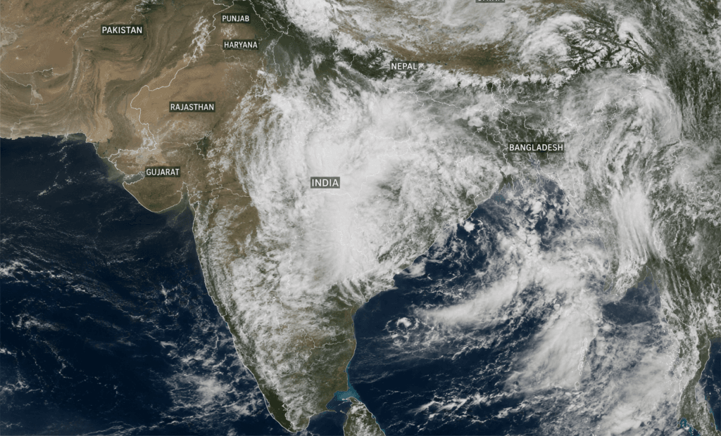
Satellite imagery highlights dense monsoon cloud cover over central and eastern India, while Rajasthan, Gujarat, Punjab, Haryana, and other western regions remain largely cloud-free amid concerns over weakening rainfall.
India’s southwest monsoon has officially covered the entire country but the latest satellite images released on Friday have revealed a worrying weather pattern. Meteorological observations suggest that active monsoon clouds are now concentrated over central and eastern parts of India, but large parts of western India, including Rajasthan, Gujarat, Haryana, Punjab and adjoining areas, are experiencing high inactivity of monsoon cloud formations.
The India Meteorological Department (IMD), meanwhile, has issued a Red Alert for heavy to very heavy rainfall in Bihar and Jharkhand, with intense rain likely to continue for the next 24 to 48 hours. Weather experts are keeping a close eye on Super Typhoon Bavi, which has formed over the western Pacific Ocean near the Philippines. The powerful cyclone, thousands of kilometers away from India, may slow down the monsoon activity over several parts of the country due to the atmospheric circulation and may temporarily reduce the formation of new low-pressure systems over the Bay of Bengal.
The latest weather news is a mixed bag. States of eastern India prone to flooding still face the risk of heavy rainfall, but farmers and residents of western India are growing increasingly concerned about the prospects for extended dry weather in what is normally an active monsoon season.
Why Are Monsoon Clouds Missing from Rajasthan and Gujarat?
Meteorologists attribute the heightened activity of the southwest monsoon over central and eastern India to conducive atmospheric conditions at present. Extensive cloud cover is seen over Madhya Pradesh, Chhattisgarh, Jharkhand, Bihar, West Bengal and the northeastern states in satellite pictures. Moisture is still permeating these regions from the Bay of Bengal, which is aiding active rainfall.
But in western India the weather is different. Satellite observations show relatively clear skies over Rajasthan, Gujarat, Haryana, Punjab and adjoining areas. This does not necessarily mean the withdrawal of the monsoon but the temporary weakening of monsoon currents over these regions.
Weather experts said the monsoon rain is highly dependent on the continuous formation of low-pressure systems over the Bay of Bengal. These weather patterns move inland, bringing moisture and heavy rains to northern and western India. If the formation of these systems slows down, then rainfall also decreases.
The current absence of dense cloud cover suggests that rainfall in western India may remain below normal over the next few days unless fresh weather systems develop.
Also read: Heavy Rain In Uttarakhand: Rockfall, Debris Shut 32 Roads In State
How Super Typhoon Bavi Is Influencing India’s Monsoon
One of the key factors behind the forecast slowdown is Super Typhoon Bavi, which formed over the Pacific Ocean near the Philippines and is heading for Taiwan and eastern China.
While the storm is some 3,000-4,000 kilometers away from India, tropical cyclones of this intensity can influence the atmospheric circulation across a very large geographical area.
Meteorologists say that strong cyclones tend to pull in large amounts of moisture and energy from surrounding regions. This process can temporarily suppress the formation of new low-pressure systems over the Bay of Bengal, which are crucial to the sustenance of India’s southwest monsoon.
Experts say the Bay of Bengal may remain less conducive for new monsoon systems to develop as long as Super Typhoon Bavi continues its march towards China. Therefore, rainfall activity over many states of India may decrease after the next two days.
But weather scientists stress this is expected to be a short-term phase, not a permanent weakening of the monsoon.
Red Alert Issued for Bihar and Jharkhand
Whereas the western parts of India are facing a scarcity of rain-bearing clouds, the eastern parts are facing the opposite situation.
The India Meteorological Department has issued a Red Alert for Bihar and Jharkhand for very heavy rainfall. Heavy rains can cause urban flooding, waterlogging, overflowing rivers, disruption of transport and damage to crops.
Local authorities have been asked to stay on high alert, especially in low-lying areas prone to flooding. Disaster response teams are also expected to stay on standby for emergencies.
The adjoining states, including West Bengal and parts of eastern Uttar Pradesh, are also likely to witness moderate to heavy rain as the current monsoon system is still active.
What Satellite Images Reveal
Today, weather satellites provide meteorologists with minute-by-minute information about cloud movement, rainfall intensity, air moisture and atmospheric circulation.
Latest satellite pictures offer a clear picture of two contrasting weather situations prevailing across India.
Dense cloud formations are over Madhya Pradesh, Chhattisgarh, Bihar, Jharkhand, West Bengal and parts of the Northeast in Central India. These areas still get sufficient moisture from the Bay of Bengal.
But western states like Rajasthan, Gujarat, Haryana and Punjab seem to be relatively cloud-free, indicating less monsoon activity.
Types of satellite observations help weather agencies to make timely forecasts and warnings of disasters. They help farmers plan agricultural activities.
Impact on Agriculture and Water Resources
The changing pattern of rainfall may have far-reaching implications for the agriculture sector of India.
Crops grown in the Kharif season like paddy, soybean, maize, cotton, pulses and groundnut, are greatly dependent on regular monsoon rain in the months of July and August. A dry spell in western India could delay sowing operations in some districts or lower soil moisture levels.
Farmers in Rajasthan and Gujarat, especially those who depend upon rain-fed agriculture, may get more worried if rainfall remains below normal for another week.
Meanwhile, heavy rains in Bihar and Jharkhand can damage standing crops through waterlogging, erosion and flooding.
Agricultural experts often note that the uneven distribution of rainfall can be more devastating than a total rainfall deficit, as different areas suffer simultaneous opposite extremes.
Background: This Season’s Journey of Monsoon in India
The southwest monsoon normally arrives in Kerala in the first week of June, before gradually moving across the country.
This year the monsoon arrived steadily and finally covered the whole country. Parts of western India faced intermittent dry spells, while several parts of central and eastern India got above-normal rainfall in recent weeks.
Earlier, weather agencies had predicted that India was likely to get near normal seasonal rainfall overall but there were likely to be regional variations during the season.
Every year, the Indian monsoon is subject to regular temporary fluctuations in atmospheric conditions, tropical cyclones and ocean temperatures.
Recent Weather Events
Earlier this month, the southwest monsoon successfully covered the entire country and several regions had widespread rainfall. In the last week, central parts of India were under active monsoon condition with Madhya Pradesh and Chhattisgarh receiving continuous rain. New satellite pictures released today showed a significant decrease in cloud cover over Rajasthan, Gujarat, Haryana and Punjab. Simultaneously, the India Meteorological Department has issued a Red Alert for Bihar and Jharkhand due to heavy rainfall. At the same time, Super Typhoon Bavi formed near the Philippines, raising fears that new low-pressure systems over the Bay of Bengal may not develop for a while, which may hinder rainfall in several Indian states in the coming week.
Why This Matters
India’s economy, agriculture, drinking water supply, hydropower generation and food production are still closely tied to the southwest monsoon and the weather development is important.
A brief dry spell in the rain and snow may not mean an immediate drought, but a dry spell of more than a week can start to take its toll on farming and reservoir storage in several Western states.
At the same time, heavy rains in eastern India present a different challenge. Serious concerns remain among millions of residents about flooding, damage to infrastructure, loss of crops and disruption of transportation.
The issue is of great importance because it connects India during the monsoon season to a situation of both floods and dry conditions, which helps in comprehending the complex issues of weather management.
India Angle
For millions of Indian farmers, the monsoon is more than just a weather event; it is a question of livelihood, food production and rural incomes.
States like Rajasthan and Gujarat depend on July rainfall for sowing crops like bajra, cotton and groundnut. Prolonged dry periods may increase the need for irrigation and increase production costs.
Meanwhile, Bihar and Jharkhand are facing the other sort of problem, where too much rain could wreck roads, schools, houses and agricultural fields.
This difference is proof of the diversity of climate in India. Within the same week, one part of the country may be fighting floods while waiting for rain in another.
Hence the government agencies, disaster management authorities and agricultural departments need to have a regionalized approach rather than treating the monsoon as a uniform phenomenon across the country.
Analysis
Weather reporting: Satellite imagery now points to a highly dynamic nature of the southwest monsoon over India. Though the headlines may say monsoon clouds have “disappeared” from western India, it is essential to point out that such fluctuations are common in the season.
The bigger worry is the possible effect of super typhoon Bavi. The formation of new weather patterns over the Bay of Bengal could be delayed if atmospheric conditions are not conducive, leading to below-normal rainfall over several states in the west and northwest in the next few days.
But historical weather patterns have also shown that the monsoon often revives quickly again, as fresh low-pressure systems begin forming once more. There is no need to panic, but constant monitoring is essential.
As a news writer you have to be just as careful not to sensationalize weather developments. Scientific explanations show readers how such changes occur rather than just scaring them about lack of rain. This story covered in Hindi by Bhaskar
What Happens Next?
The meteorologists said heavy rainfall is likely to continue over Bihar, Jharkhand and neighboring eastern states during the next two days.
After that period rainfall activity is likely to decline over several parts of India if no fresh low-pressure system develops over the Bay of Bengal.
Weather agencies will track Super Typhoon Bavi’s progress toward China. If the cyclone weakens or moves away from the area, atmospheric conditions may once again become favorable for the formation of monsoon systems.
If the weather conditions develop as predicted, experts say western and northern India could experience widespread rainfall in about a week.
Citizens are advised to follow the official weather bulletins issued by the India Meteorological Department, especially in flood-prone districts.
Conclusion
The latest satellite pictures reveal a huge difference in the monsoon pattern in India. Active rainfall persists over the central and eastern states with Bihar and Jharkhand under a Red Alert but monsoon clouds are not seen over western India for now. Another element of uncertainty for the country’s weather forecast is the possible effect of Super Typhoon Bavi on atmospheric circulation.
While the rainfall slowdown is likely to be temporary, the effect on agriculture, water resources and local economies cannot be ignored. The eastern states will continue to experience heavy rain and need to stay alert for flood-related hazards.
The monsoon in India has never been predictable but with modern satellite technology and better forecasting, authorities are now able to respond more effectively. The coming week will be crucial in deciding whether the monsoon picks up again over western India or the dry spell continues.